Sea Australia is dedicated to the protection of
the marine environment and providing a quality and timely service to its
customers locally and internationally.
Whether our customers are private companies,
non-government organisations or government agencies we pride ourselves on
being flexible to meet the demands of customers in emergency situations that
can occur anywhere and anytime. Whether your incident is a large or
small-scale spill, Sea Australia personnel can offer a range of professional
and technical services to meet your needs and budget.
Please do not hesitate to email us if you have
any queries or wish a quotation on any services.
Among the portfolio of services and expertise
we can provide the following:
-
Spill Contingency Planning, Response
Preparedness and Consultancy Services
-
Environmental Sensitivity
Assessment, Mapping and Geographic Information System (GIS) Services
-
Assessment
and Monitoring of Pollution Impacts on Marine and Coastal Habitats
-
Environmental Impact Assessments (EIA)
-
Contaminated Shoreline Assessment, Cleanup and
Treatment Advice (SCAT) and Services.
-
Spill Information Management
(SIM)
-
Baseline Environmental Surveys for Ports,
Marinas, Harbours and Coastal Developments
-
Sampling Surveys – Water, Air and Land
(Analytical Services provided by Leeder Consulting)
-
Spill Trajectory Modelling (Services provided by
ASA-Asia Pacific)
-
Company/Site Specific Marine Pollution Risk
Assessments
-
Shipwreck Data – ID and
Location of over 8000 WWII shipwrecks globally
-
Oiled Wildlife
Planning and Response.
Environmental
Sensitivity Assessment, Mapping and Geographic Information System (GIS)
Services
We provide a range of spatial analysis and
ecological mapping services, for contingency planning and incident response,
these include:
-
Environmental Sensitivity Mapping (ESM)
-
Resources At Risk (RAR)
-
Fate and Effects (FAE)
-
Contaminated Shoreline Assessment, Cleanup and
Treatment Advice (SCAT) and Services
-
Compilation of site environmental data into GIS
maps and the overlay of data on satellite imagery or aerial photographs.
Assessment and Monitoring of Pollution Impacts on Marine and Coastal Habitats
The key to accurate and defensible impact
assessment during marine pollution incidents is a sound understanding of
aquatic ecological and physical processes. Sea Australia personnel can provide
a range of environmental monitoring and assessment services during an
incident. We can provide sampling surveys for water, air and land and
analytical services through Leeder Consulting.
Spill Information
Management (SIM) Services
SIM Services provided by Sea Australia is
essentially the documentation of environmental damage and incidents for
investigations, resource damage assessments, response activities and cost
recovery purposes. Traditional survey and environmental reports can be complex
and lengthy. Increasingly we are using GIS based mapping linked to data,
pictures, video and textual information to provide clear and interactive
information for decision makers.
Data is gathered by a thorough and objective
site investigation covering all aspects of the pollution incident and evidence
collection by skilled environmental personnel. Site/incident information, site
surveillance, geographic coordinates and observations undertaken by our
personnel are backed by systematic video and photographic surveys.
These surveys can include:
-
The movement and location of the spill over time
-
Identifying habitats impacted and resources
damaged
-
Monitoring cleanup actions and
equipment/manpower deployment
-
Provision of an interactive map on CD-ROM to
ease the reconstruction of the incident and response actions.
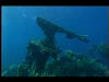
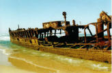
Shipwreck Data – ID
and Location of over 8000 WWII shipwrecks globally.
The Sea Australia Services offers an insight
into the possibility of marine pollution caused by ageing
WWII shipwrecks.
Sea Australia aims to accumulate all the most recent
and up to date information on WWII and its shipwrecks and the consequences of
such marine pollution events. Please see our
'Publications' page for recent papers, abstracts and presentations.
Our consultancy offers map making services for our
customers interested in the location, size and further information about WWII
shipwrecks.
Oiled Wildlife
Planning and Response
Contact
Please email us with your direct request and we
will endeavour to get back to you soon with a detailed quote.
 Email us now!